Béatrice GISCLARD, Designer and Assistant Professor in Design at the University of Nîmes, she is joint director of the Design Innovation Society Master's program. She holds a doctorate in geography from the University of Avignon and is an associate member of the Center for Interdisciplinary Studies and Research on Public Safety and Emergency Preparedness in Aix-en-Provence.
Michela DENI, Full Professor in Semiotics at the University of Nîmes, she is director of the Projekt Lab and joint director of the Design Innovation Society Master's program. She holds a PhD in Semiotics from the University of Bologna (thesis supervised by U. Eco) and a post-doctoral diploma from the University of Limoges. Her work focuses on the semiotics of design project methodology, and didactics in design.
Alain FINDELI, Honorary professor of the University of Montreal, he is cofounder of the Design Innovation Society Master's degree program of the University of Nîmes, the Ateliers de la Recherche en Design, and the first research team in social innovation through design, UPR Projekt. He boasts 40 years of research activities in design theory, methodology and pedagogy.
Abstract
Throughout history, human societies have had to face deal with natural disasters that unpredictably disrupted their social and cultural balance. Human and financial losses due to natural disasters are becoming ever greater, questioning whether current risk management policies are up to addressing the various issues involved. The present study focused on the specific issue of flash floods in the south of France and the means of development of local inhabitants' capabilities through social design and a fresh approach to risk communication. It demonstrates that an interdisciplinary approach to the complex issue of flooding leads to a better assessment of the role of local populations, by enhancing collective and individual skills (through social design) and highlighting the importance of risk communication (through semiotics). More generally, we hypothesize that proper natural risk management offers considerable potential, but this has yet to be fully explored in the field of design.
Résumé
Tout au long de l'histoire, les sociétés humaines ont dû faire face à des catastrophes naturelles qui ont perturbé de manière imprévisible leur équilibre social et culturel. Les pertes humaines et financières dues aux catastrophes naturelles sont en augmentation, ce qui remet en question la capacité des politiques de gestion des risques à répondre aux différents enjeux. Cet article se concentre sur la question spécifique des crues rapides dans le sud de la France et sur les moyens de développer les capacitations des habitants par le biais du design social et d'une approche renouvelée de la communication des risques. Il démontre qu'une approche interdisciplinaire du phénomène complexe des inondations conduit à une meilleure évaluation du rôle des populations locales en renforçant les compétences collectives et individuelles (par le design social) et en soulignant l'importance de la communication des risques (par la sémiotique). Plus généralement, nous faisons l'hypothèse qu'une gestion adéquate des risques naturels constitue un domaine à fort potentiel mais encore peu développé en matière de design.
Introduction
Natural hazards were traditionally feared as because they upset the balance of society, and they were usually attributed to external causes (divine punishment, Mother Earth expressing her displeasure, etc.). According to longstanding social1 and cultural2 constructs, risk, therefore, has no objective existence. It is nonetheless an interesting marker, as it reveals, how populations see themselves, through the definition of the dangers that threaten them and the strategies they put in place to deal with them.
We looked at the importance given to individual flood management policies in France, by studying how these risks are formulated by the authorities and how they are potentially re-appropriated by local inhabitants through social design and semiotics. Communication issues and risk-mitigating actions appear equally crucial to the individual understanding of danger. After describing our multidisciplinary approach (design, semiotics and geography) to analyzing risk, as expressed in interviews and discourses, as well as institutional policies, we suggest ways of constructing a meaningful narrative. We end by highlighting the potential for social and territorialized innovation through the creation of a social design workshops, built in collaboration with local inhabitants. This study was conducted as part of a doctoral study3, supplemented by a semiotic study4.
1. Flood Risk Challenges: The Social Construction of Risk
Flood risk management essentially relies on weather forecasts and structural measures (dykes, dams), supported by ad hoc public policies. Even when there are copious historical data records, memories of past disasters seem to be linked to the social context that prevailed at the time, such that one event may be remembered and another forgotten regardless of their severity. For example, the month of October 1940 saw the highest rainfall ever measured in Europe5, but this was overshadowed by the Second World War. Therefore, studies of natural disasters require a relativistic approach, taking into account not only physical data and research findings, but also the political, social, historical and cultural context, in order to analyze all the processes that led up to each event.
Awareness of the interactions between human development and ever greater environmental problems has gradually increased since the post-war period. The United Nations declared the 1990s to be the International Decade for Natural Disaster Reduction6, with the aim of reducing the impact of natural disasters in developing countries. However, subsequent events gradually undermined the assumption that developed countries are resistant to natural hazards, while developing countries are always more vulnerable, as they lack the resources to protect themselves. The Western world is therefore becoming ever more aware of its own vulnerability, with the increasing complexity of social and technological systems7.
Disasters have lasting effects on national economies, and may permanently disrupt social relations8. Between 2000 and 2015, the United Nations Office for Disaster Risk Reduction (UNDRR) moved from a strategy based on vulnerability to one based on resilience9. It is worth drawing attention to the speed with which public authorities have appropriated the concept of resilience. This semantic shift has forced people become involved and react. To be resilient means to be able to absorb and overcome the shock of a disaster. This means that extreme events are no longer viewed as external to individuals and their community. The latter are therefore required to be proactive in preventing potential damage, adopt appropriate behavior, interact with the authorities during the crisis, and address post-crisis situations. Natural disasters have gradually become a feature of the "risk society" as described by sociologist Ulrich Beck (1986)10. Of all natural disasters, flooding is the type that generates most damage worldwide. Between 1998 and 2017, floods affected more than 2 billion people across the world11, and they constitute the most common and most damaging extreme event in France. Flash floods occur after a heavy bout (2‑6 hours) of rainfall, creating fast-moving flood waves. These hydro-geomorphological characteristics make them difficult to predict, despite recent advances in weather forecasting. The Mediterranean coast of Southern France is particularly exposed to this risk. Given the substantial costs (human, social, financial, structural) of flooding, it is important to understand how the it is managed by institutional stakeholders. In France, flood risk management takes place in three phases: 1) prevention, 2) crisis management, and 3) reconstruction. Not only does each of these phases depend on a different ministry, but responsibilities are spread across numerous administrative levels: (municipal, local, zonal, regional, and national12). The 2004 Civil Security Modernization Act stipulates that "everyone contributes to civil security through their behavior". Beyond the likelihood of a natural hazard occurring and its controllability, both institutions and inhabitants are gradually becoming aware of their respective limits when faced with such risks. The latter are only managed by applying a rational approach to data, information, resources, and protocols (before, during and after the event).
This complexity led us to explore a social innovation approach from an interdisciplinary action perspective. Achieving behavioral change requires people to be involved in a project not only as final recipients, but from the very outset (i.e., project design phases). The hypothesis put forward here is that the effective involvement of individuals through the co-design of solutions tends to increase their capacities and thus improve their behavior. Focusing on the vulnerability of rural France to flood risk, and more specifically to flash floods (additional vulnerability factor), the present research drew on three scientific disciplines (risk mapping, semiotics, and social design), as these all concern humans' interactions with and interpretation of their environment.
2. Method
Between 2014 and 2016, we conducted 65 non-structured interviews with risk managers (36) and those affected by the risk of flash floods (29). Analysis of transcripts highlighted three key points: inhabitants are viewed as abstract figures in risk management, alerts can create misunderstandings during flooding, and there is a gap between the temporality of the event and daily habits. The convergent discourses of the two groups we interviewed on issues related to communication, suggested that a semiotic study could considerably enrich the analysis and help build a narrative that would makes sense to both groups.
2.1 Semiotic Material
Semiotics can explain some problematic aspects such as communication, reception, interpretation, and misunderstandings, and help reduce the gap between a design project's intention and its reception. Furthermore, environmental design makes it possible to assess the potential implementation of design intentions and lead to actionable projects. The pilot communities were chosen using nested methods. We began by using geographic information systems (GIS) to map flood risk areas. The sheer range of flood risk area maps available (AZI, PPRI, TRI, EAIP13), the heterogeneity of the methods used to create them, their equivocal nature, and political14 considerations15 provided us with a rich vein of research material. The use of mapping to define flood risk areas is a major source of tension between local populations, policymakers, and institutions. This often questionable process gives rise to difficult negotiations that highlight both political and technical power struggles16. Far from being a simple transposition of potentially affected areas, mapping primarily involves defining and therefore negotiating risk. The multitude of available methods, some of which were created in an inconsistent way at an institutional level (community or European), and according to different timeframes, is extremely confusing for local inhabitants. Furthermore, the choice of visual design principles is challenging for both designers and semioticians, as there is a striking lack of coherence (different color schemes, contrasts, plans, reliefs, etc.). Like any representation, maps cannot be reduced to their technical and regulatory aspects, as they also have to support the stakeholders who act as mediators between laypeople and experts and, more widely, as a political expression of risk management.
After this initial selection based on risk mapping, we compared local communities on indicators of territorial vulnerability and social dynamics. This process yielded four municipalities (two in the Gard département, and two in the Vaucluse département) for further investigation in the field. The first series of interviews with risk managers highlighted the abstract nature of the concept of the involved inhabitant, and went back and forth between institutional orders and individual behavior in the event of flooding. We therefore contrasted this top-down approach aimed at making people act with the local inhabitants (bottom-up) perception, which was conditioned by the knowledge / ability / desire / obligation to act. Given the need to engage with the population concerned by flood risk, we pointed out that engagement strategies would benefit from appropriate flood risk communication. Given the legitimate desire for a return on investment, regarding communication budgets, it is important to gauge the potential impact of these campaigns. Our analysis of existing information resources led us to question their visual and communicative efficiency. The aim of these resources is to enable inhabitants to understand the data they are given, be aware of the emergency, and act accordingly.
2.2 "Flood Watchers" Workshop
We conducted complementary research between 2015 and 2017, by sending a questionnaire on risk perception to the residents of the four selected municipalities. This research had two main objectives. First, we sought to gain an in-depth understanding of how individuals perceive risk management systems, in order to identify their motivations to act (the ability and/or desire to act may depend on several factors, according to the individual's pragmatic or cognitive skills) and their socio-spatial and temporal framing of the risk (Fig. 5).
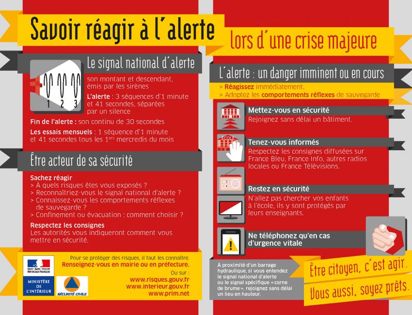
Figure 1. Guidelines for good practices17.
Second, we set out identifying the most fertile ground for social innovation, the first outcome of developing new skills among stakeholders18 in the context of flash flooding. Research on these types of initiatives at a national level has shown that they remain marginal and disparate. An interesting example was nevertheless identified in the Lyon region: the Sentinel network19 composed of people living in towns and villages upstream warning people living downstream of potential flooding (Fig. 4).
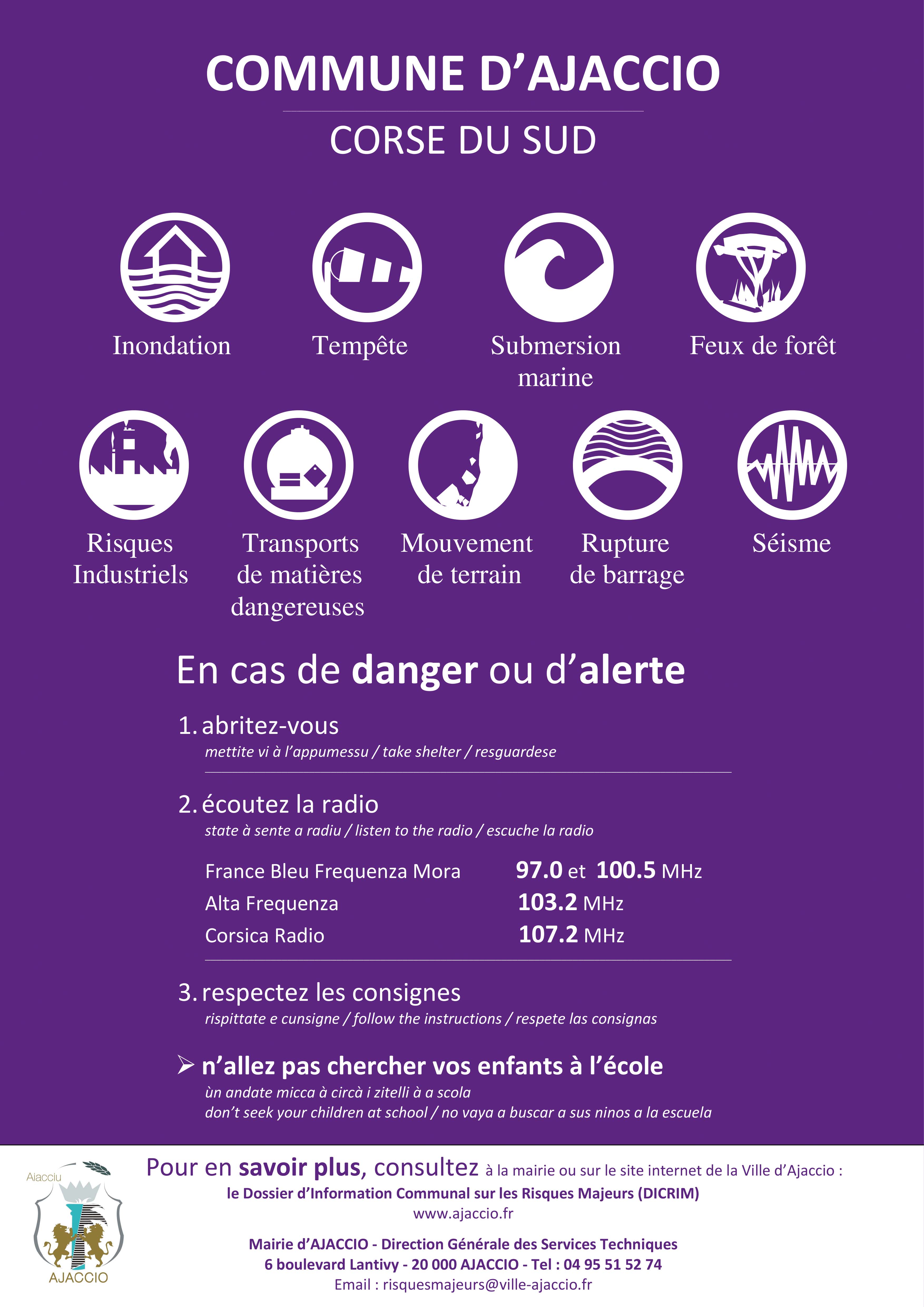
Figure 2. Community poster on major risks20.
The results of the interviews and questionnaires were used to create a prototype for a social design workshop implemented in the village of Sauve, in the Gard département. The long period (18 months) allocated to the field research was necessary not only to administer the 689 questionnaires and conduct the interviews, but also to better understand local specificities, which would have gone unnoticed had we adopted a more superficial approach. Although no study can fully cover the complex social dimensions of a given place, the time spent in the field in different seasons, the bonds of trust that we established through the interviews, and the data we collected on past floods formed the backbone of our study and highlighted the relationships that local inhabitants maintain with the flood risk. The Gard département (where the town of Sauve is located) is particularly badly affected by Cevenol episodes (heavy Mediterranean rainfall causing flash flooding), and its local people have developed specific skills in terms of flood risk management21. Our partner was La Bobine, a social design agency22. Our main focus was on designing specific skills-based flood risk management tools, which -had previously been the remit of engineering consultants (i.e., hydrology and weather experts). Our team designed various tools specifically adapted to this community and to the type of flash flooding risk experienced on the Vidourle River23. We had three main objectives: 1) initiate an inhabitant-oriented approach, distinct from the institutional framework (regarded as too standardized and codified), 2) study the potential interactions between inhabitants facing flooding through group role play, and 3) lay the groundwork that would allow them to claim ownership of these complex issues, as the French Government has invested on average nearly 15 million euros per year in prevention policies, without making any effort to ensure their ownership by local inhabitants' or their efficiency at a local level.
Although they are a valuable resource for understanding floods and risk-related processes, questionnaires and interviews do not generate interpersonal relationships or collective dynamics between the stakeholders. We can use them to encourage local people to engage in a process of reflective reflection and recollection but not to adopt a pro-active approach to future flooding events. We therefore decided to set up a workshop to put social innovation into practice and study its potential regarding flood risks. The name Flood Watchers met various criteria: referring to overflowing and not flooding, it detracts from flooding as a social phenomenon and its negative connotations, rather than focusing on the physical dimension of the hazard. The notion of being on watch (veille in French) obviously implies a lower of attention than being vigilant. Veille is a familiar term, as it also used to describe the standby mode of electrical devices, the latter's discreet presence meaning that the device is always ready. Regarding visual identity, we chose the color yellow, in direct reference to the lowest level of vigilance used by the flood forecasting service of Météo-France named Vigicrues24. The jointly designed tools for the Flood Watchers workshop were inspired by the Vision +21 toolbox, developed by SDS22 in collaboration with the French Environment Ministry in 201425. They refer to what Schaeffer (2005)26 calls playful pretense, which leverages children's mental ability to act as if, through the principle of immersive simulation that fosters the development of social cognition. Schaefer describes this fictional environment as a closed world. Individuals do not have to believe in it as they understand that it is fictional.
3. Results
3.1 Making Sense: Narrative Construction
Our analysis is focused on the interviews conducted with civil security managers officials from the Ministry of the Interior, on the subject of documents and websites dealing with the issue of vigilance and warnings. This corpus highlighted a general issue about the construction of meaning, as the first rule of communication is to provide information that makes sense for the targeted audience (for an example of a poster produced by the Ministry of the Interior, see Fig. 1).
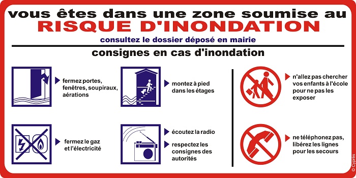
Figure 3. Behavior guidelines27.
On this basis, it is important to remember at least two general points. First, a meaningful discourse requires a good narrative construction and structure to engage stakeholders. If the latter does not respect certain rules (current situation, reason why it has happened, steps to follow, positive or negative effects), the meaning of the message will be difficult to understand, identify, and memorize. This communication requires the use of a clear and explicit conventional narrative pattern, first in both its in-depth structure (content organization: series of phases and events) and its discursive and figurative implementation (mapping, graphic design, and how this content is represented).
Second, risk communication generally gives rise to several different documents, often issued by the same institution. The meaning of informative messages therefore travels through various media and communication typologies. In other words, there is a fragmentation of general communication, which should be regarded as serial. We therefore observe a narrative organization that is both global (information campaigns) and ad hoc (each communication being a component of the global organization).
The semiotic aspects of the maps and graphics we analyzed, and their possible interpretations by end users (i.e., local inhabitants), led us to adopt an integral approach, allowing us to identify the most typical elements of these communication methods. In most cases, the visual documents, classified as information, warning, or action instructions, were intended to prevent address and control risk (Figs. 1, 2 & 3).
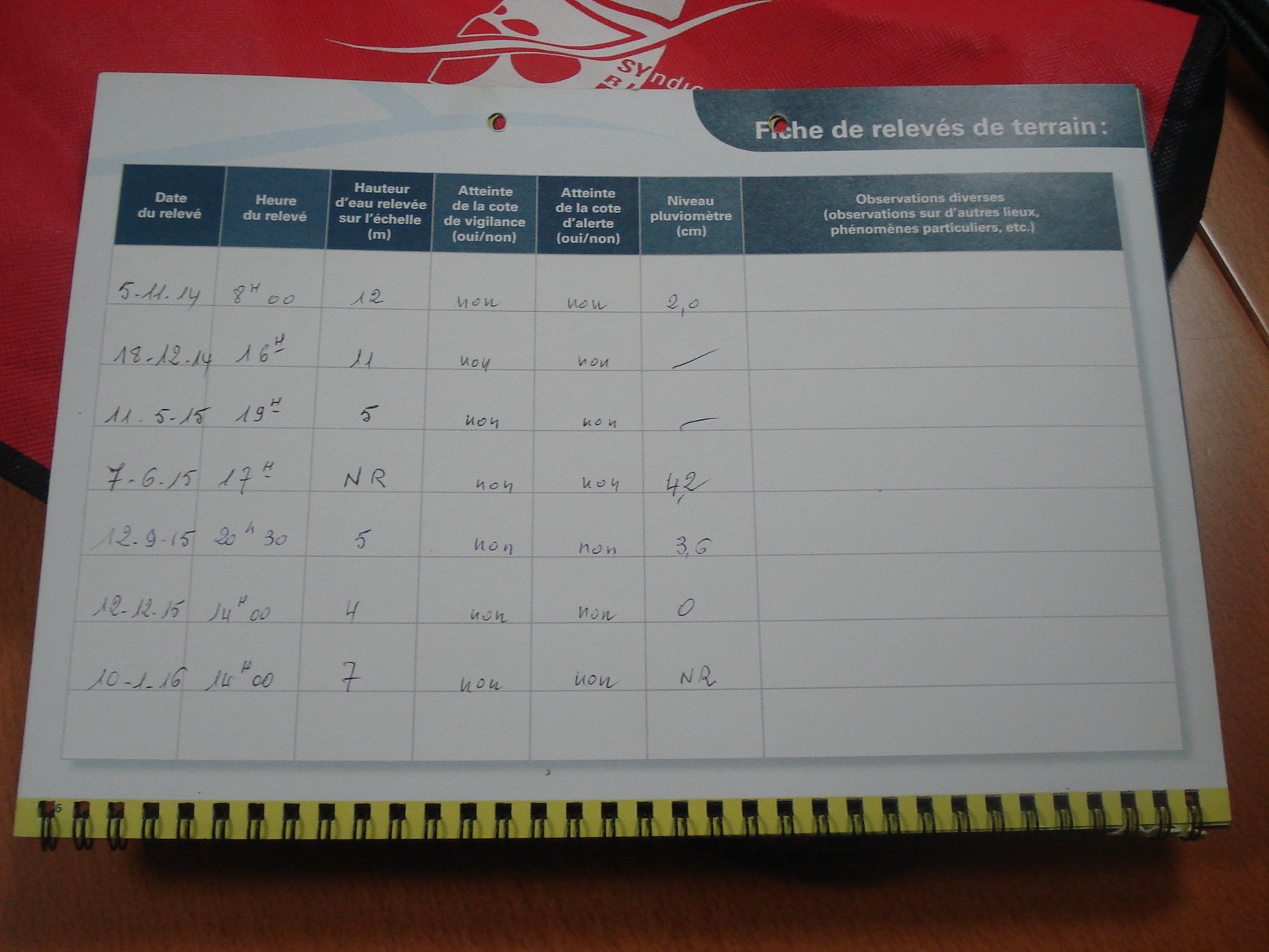
Figure 4. Water levels recorded by members of the Sentinel Network of the Brévenne and Turdine rivers, Rhône département.
In semiotic terms, these communicative approaches involved manipulating the cognitive and pragmatic dimensions (here, moving from knowing to believing, and thence to doing28). Manipulation (without any negative connotation) is the first step in each narrative pattern: it is the implicit or explicit discursive configuration of any story. It begins with the fiduciary contract stipulated in each communication between the communicator and the recipient. Here, manipulation is simply the enactment of a persuasive act. It is an extremely important instance of activation, both for the narrative content (what is said) and for attracting the audience's attention.
In semiotic terms, the function of informative communication is to make people aware (e.g., "You are in a flood risk area" in the first part of the visual; Fig. 3). The second step is the warning phase — the enactment of make-believe —, and the third and final step is the instructions for action, a traditional and pragmatic method, ending in action (instructions in the visual; Fig. 3). It is important to understand that the construction of each phase is fundamental in the gradual building of meaning, allowing inhabitants to engage. If this narrative sharing of information works (i.e., if the communication authority is recognized), recipients will pay attention and incorporate the message into their own field of references, and the objectives of the communication will thus be reached. The first two know and believe steps are key to being able to follow instructions: (e.g., what to do / what not to do) and act.
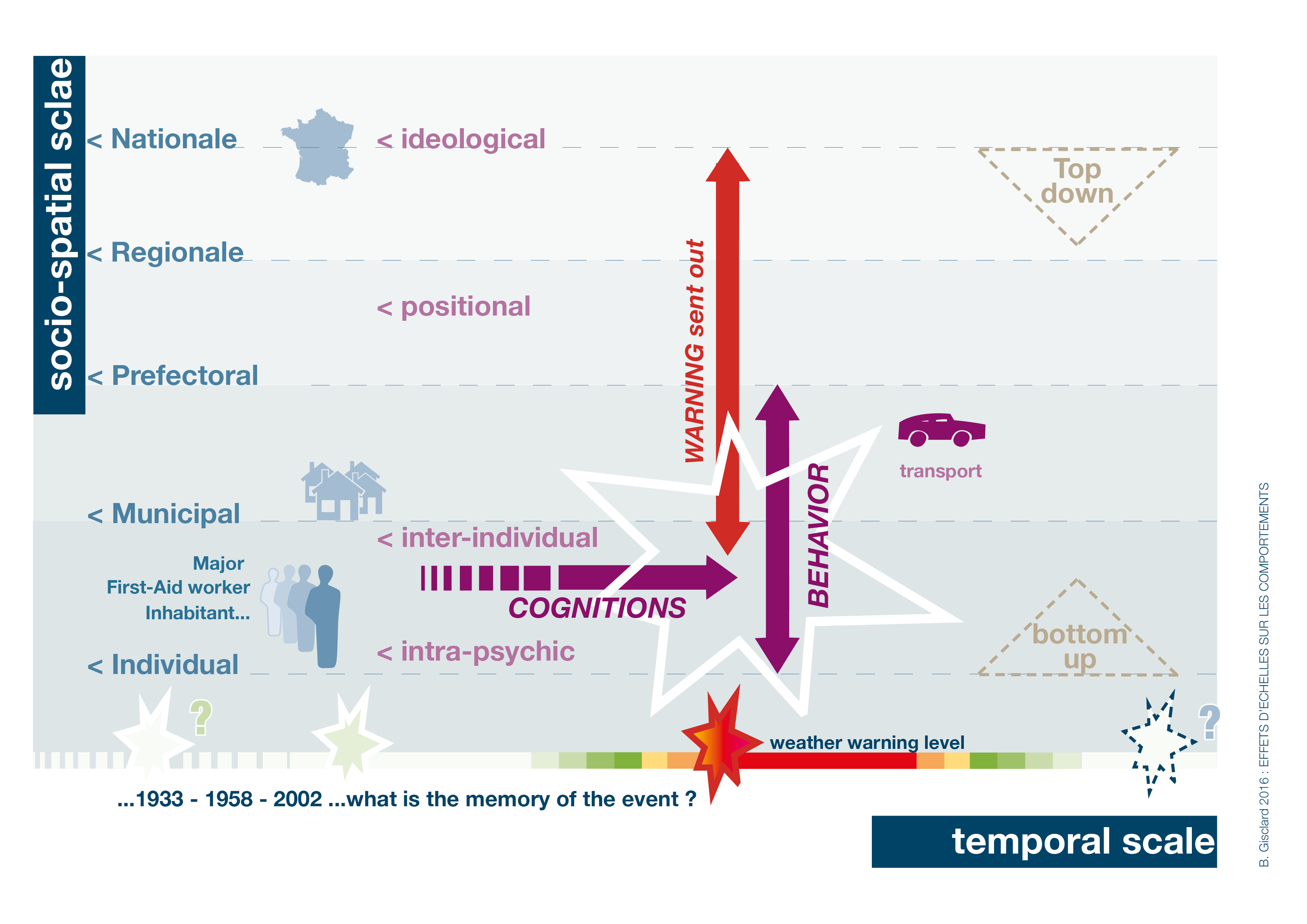
Figure 5. Behavioral scale effect
Maps and infographics designed to inform use the same typologies as institutional documents, telling people which relevant authorities to inform and who will provide the rescue services. This aspect may seem self-referential and difficult to understand (Fig. 1) but it is actually very important, as it emphasizes the authority and credibility of the communicator, as well as the legitimacy of an individual or institution. From the communicator's point of view, this is a legitimate communicative intention, but we noticed that its communicative transposition does not always achieve the expected clarity, with targeted individuals failing to understand either the usefulness or the purpose of the message. Not only is the communicative intent difficult to identify, but the visual representation of institutions and institutional roles becomes even more abstruse, as recipients do not see why it is necessary in that particular context ("why now?"). The communicative intentions remain unclear and seemingly pointless, and can therefore be ignored29 (Fig. 1). This means that when the time comes, individuals will not necessarily remember who to believe or who to contact when needed, given that in an emergency situation, fear and panic can reduce people's cognitive ability to understand messages.
Some infographics focus on warning messages: visuals designed to raise awareness of the importance of meaningful information that may soon prove meaningful. The How to react to the alert visual (Fig. 2) is an example of a communication warning about a situation that is quite distinct from the individual's reality. It is linked to various alert signals. As it has no tangible meaning and is not related to the individuals' direct experience, this type of message heightens stress during the alert: the latter's duration and high-pitched tone of the sound is fundamental for people to understand the meaning and nature of the alert, but we are aware that when the alert actually takes place, people are unable to objectively calculate the length and tone of the alert sound. This means that the effectiveness of the warning depends on the degree of trust placed in the communicator (the recipient accepts the communicator's authority) and on the experience (direct or indirect) of each individual. More efficient messages, designed to make believe, use elements from the target recipients' real world, such as scientific risk data (statistical data, hydrology data, etc.). These (verbal or visual) messages are based on the narrative of the known or imaginable reality of those living in a flood risk area. In these cases, the persuasive and narrative power of the message is based on what the targeted individuals have experienced, heard or seen. This emphasizes the importance of organized groups such as the Sentinel Network, which are deemed credible because they are made up of people whose competence is rooted in real-world experience, and not only in abstract knowledge (Fig. 4).
The last step concerns the instructions for action provided before, during and after the flooding event. This communication involves using figurative elements in order to construct scenarios that evoke individual experiences when facing risk. In semiotic terms, it is aimed at making people act, a key moment in any semiotic manipulation, and it cannot succeed unless previous communications has been taken on board.
3.2 Territorialized Social Innovation
During the workshop, the activities offered to participants were divided into two phases. During the first phase, entitled Sauve in 2030, participants were shown five fictional newspaper articles. These were about a disaster supposed to occur in 2030 in the Gard département, inspired by the main topics highlighted in the interviews: weather forecasting, dam failure, insurance cover in the case of a natural disaster, recollection of events, and mobility during flooding events. The groups had to select one of these articles and describe the actions and strategies implemented by the inhabitants of Sauve to avoid or minimize risk. The second phase was a collective "game" called 24-hour flood. Teams were asked to describe their individual and collective actions during the 24 hours of intense flooding also supposed to occur in 2030 in Sauve (Fig. 6). We postulated that fiction is not only a lever for debate but also for action by local stakeholders. It provides the keys to action by anticipating different scenarios to empower citizens and help them learn, through experience, how to deal with these natural risks, which require, not the application of tools, but anticipation and creativity in order to rapidly redefine an organizational vision.
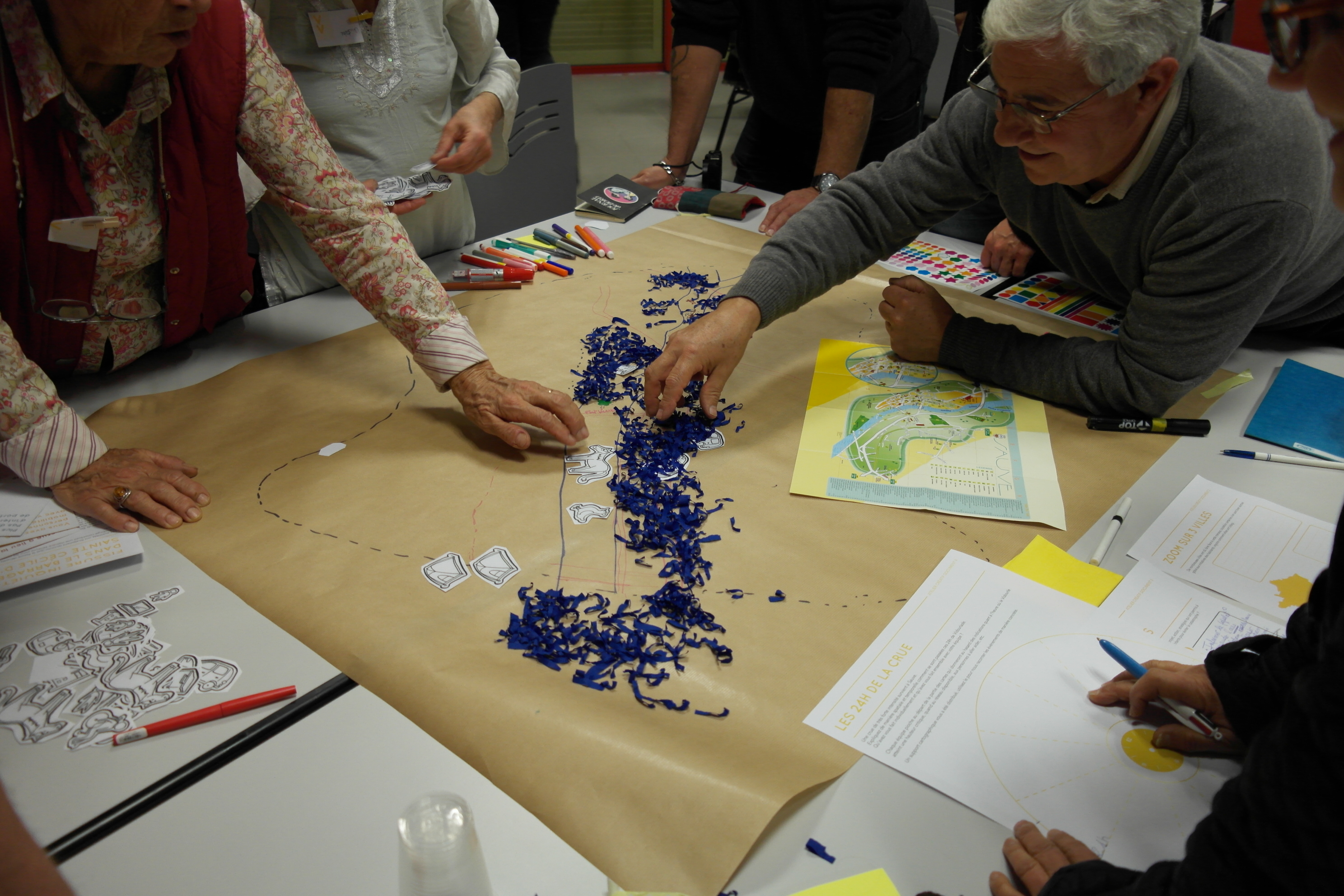
Figure 6. 24-hour flood
Each team had to pick a card describing a particular context (a person with reduced mobility, with children, etc.), time (night, morning, etc.) and the status of communications networks (no network, available network, etc.). This activity allowed participants to engage in roleplay in different flood contexts and come up with different proposals. Although the flood scenario was set in the future, these cards gave a realistic framework for action, without restricting participants' imagination. Participants then had to explain their movements and behavior with various tools. Two teams had access to local maps: an aerial view and a SCAN 25®IGN map30. The other two teams only had blank sheets of paper. We had observed that maps of the area play an important role in risk management. Flood risk areas were therefore deliberately hidden, and participants had to identify them according to their recollection of past floods. At the end of the session, each team selected a spokesperson to create a video diary for the other participants. The groups selected the best proposal, and a Flood Watchers certificate was awarded to each participant at the end of the workshop. Particular attention was paid to communication materials (Fig.7).
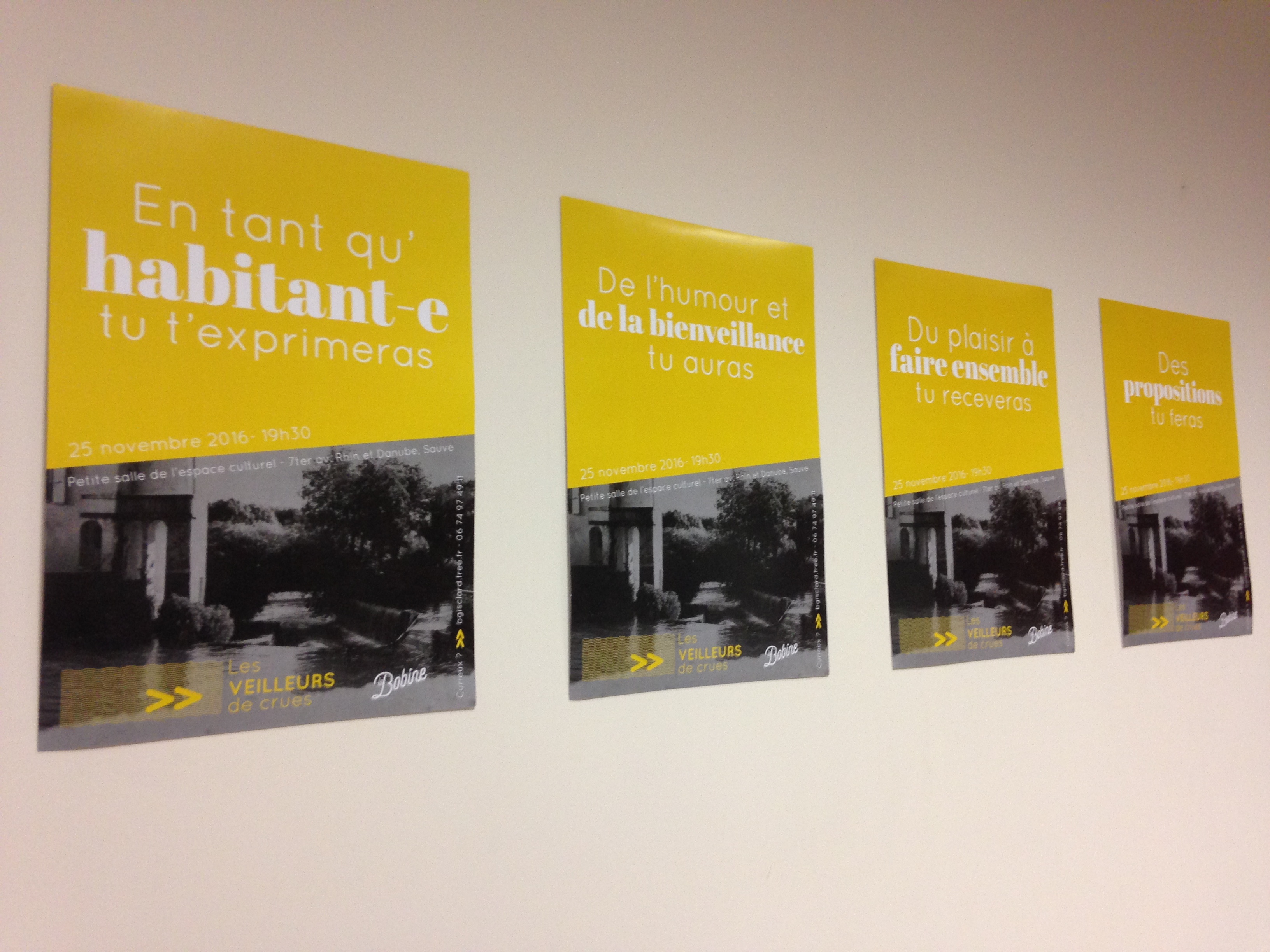
Figure 7. Flood Watchers posters
The posters explaining the rules of the game were deliberately humorous. They focused on sharing and collaboration, in order to avoid, bias, non-objective statements, and nonconstructive criticism as far as possible. Risk management is often controversial, and there are frequently misunderstandings between inhabitants and authorities. It was important to defuse potential conflicts and promote dialogue, which is why we did not want local elected officials to take part in the workshop. In what Callon et al.31 call hybrid forums, groups of heterogeneous actors are brought together around a specific problem. Relying on creative methodologies from the fields of design, they are invited to develop sketches, and prototypes that allow for immersion in the objectified fictional universe. In other words, they materialize the collectively imagined ideas and experiment with them, thus leading to ideation. Through this shift from praxis (i.e., way of proceeding, practice) to poiesis (i.e., aiming at an external, unrealized goal), individuals appropriate complex or controversial objects, engage in a dynamic in which they become a stakeholder, and develop their abilities.
4. Questioning Risk Management through Social Design
At this stage of the experiment, the proposals made by the participants were unworkable. The tight schedule imposed on us exacerbated the forward-looking approach and did not lead to tangible implementation. The right balance had to be struck between a sufficient level of quality to create an ad hoc response and a planned and chosen do-it-yourself approach, minimizing the distance between laymen and experts. We also had to strike the right balance between a duration that was short enough not to discourage participants, and long enough to create appropriate engagement. A storyboard was created beforehand, detailing each phase of the process and identifying the elements needed to make the workshop a success.
The most meaningful outcome of the project was the collaboration between inhabitants. It allowed them to show their creativity through roleplay. The representations of flood risk areas were studied through different maps and were very varied, depending on the participants and the materials. The results were discussed during a debate that highlighted the complex issues linked to flooding and the collective vision of what are generally individual practices. Social design made an important contribution, thanks to the participants' feedback, on the quality of the tools (posters, cards, visual identity, etc.). Participants took greater ownership of the context than they would have done with more traditional tools (oral discussion, paper, pencils). We found their commitment and the effort they put into designing their proposals particularly encouraging and constructive. The results were modest, but they helped people become aware of the risk and open up avenues for collective action, for it is shared memory that determines and builds social event recollection32.
The participants expressed their pleasure and satisfaction in taking part in the workshop, despite the seriousness of the subject. The playful aspect was a key element of codesign33, for besides the usefulness of the what if... approach mentioned by Schaefer, games are a creative activity34. In a fun setting, the designer calls homo ludens35 to action, creating a free yet constrained environment (a game has rules and a defined space) where imaginations can run free. When we play, we play seriously: with attention and not casualness. Combined with the project narrative, this playfulness contributed to the design, and the outcome was very different from the contributions obtained during interviews or focus groups. Individual participants, when confronted with other participants, were able to go beyond making simple statements and fully share the concerns of the community.
A better understanding of the issues therefore helped to improve representations: water was no longer seen as a threat, but as an integral part of the landscape, both geographically and culturally. Living in this area meant considering all its positive and emotional values, and not just perceiving it as a high-risk zone, while living with the risk consciously and responsibly, and taking back ownership of the place on a day-to-day basis. Incorporating social design into risk management policies could help inhabitants switch from today's risk management approaches, managed by institutions, to a more collaborative process leading to empowerment and ownership. Moreover, strategies to engage people, as is the case with social design, communicative approaches and action strategies should be adapted from the actual experience of those involved.
Using social design allowed participants to re-evaluate underrated skills and to take ownership of the flood risk in their area, which cannot be done through a normative framework and institutional action. This novel approach perspective opens up opportunities for both public authorities and designers, as few designers working on social innovation currently address natural hazards. And yet, flooding currently impacts more than one third of all French communities, and this proportion is set to rise36. Today, every government in the world is concerned by natural risks of some kind (coastal flooding, earthquakes, volcanic eruptions, hurricanes, etc.) State-level risk management is necessary, but tends to neglect its reception by individuals and interactions among populations. By adopting a bottom-up approach, designers can integrate local and territorial issues and, through prototyping, can quickly test their hypotheses (with real people), in collaboration with institutions.
This first experiment obviously did not overcome the limitations pointed out by Kristina Niedderer et al.37 concerning the perpetuation and generalization of the innovations offered by social design. How can we scale up a local issue and integrate contextual differences to build a public policy ? How can the resulting public action make sense to the entire population, without ignoring local specificities38? We should remember that in the end, local inhabitants will only take ownership of the natural risk if safeguarding responsibilities are shifted to the local community. The notion of empowerment attracts little attention at an individual level in a country as centralized as France, and the road to the autonomy of inhabitants and communities remains a difficult one. Social design allows us to go beyond simply applying projection techniques. Faced with the current challenges, speculation is one possible response, which allows different directions to be tested in order to develop a project in a collective way. Beyond semiotic technicalities39, it is also clear that the communicative effectiveness of any information and prevention campaign requires long-term and multi-level narrative coherence, if it is to be understood and owned by those who are involved or who are likely to be (Fig. 2).
Conclusion
We limited our study to flooding in France, bearing in mind that the issue of natural risks is a complex and multilevel one that reflects the way societies perceive their relationship to their environment at any given time. Our analysis of institutional prevention and alert management through different perspectives — including semiotics — underlined the central questions of individual and collective ownership of public flood risk management policies. Our codesign of a pilot workshop for local inhabitants in a rural area concerned by this risk and weakened by the effects of the NOTRe Act40, highlighted the potential contribution of social design to this issue.
We argue that such empowerment is indeed possible and that organizational constraints are becoming increasingly flexible. In this context, we regard the development of social media in emergency management (SMEM) as a sign of citizens' empowerment in this domain and the positive external impact of digital social networks as useful tools during flooding alerts41. We will conclude this paper by reaffirming that natural hazards are a vast domain field of research and practice for design and designers. Addressing this field through social design can reveal interesting ways of highlighting inhabitants' capabilities.
Declaration of interest statement
This project was made possible thanks to a research grant from Avignon University (France). The authors below certify that they have no affiliations with or involvement in any organization or entity with any financial or nonfinancial interest in the subject matter or materials discussed in this paper.
References
Beck, Ulrich, Risk society. Towards a new modernity, Thousand Oaks, California, SAGE, 1986.
Callon, Michel, Lascoumes, Pierre et Barthes, Yannick, Agir dans un monde incertain, essai sur la démocratie technique, Paris, France, Seuil, 2001.
Deni, Michela, Gisclard, Béatrice, « Le design dans la gestion de la communication du risque : apports sémiotiques », in Zinna, Alessandro and Ivan Darrault-Harris, Formes de vie et modes d'existence « durables », Toulouse, France, CAMS/O, 2017, p. 67-91.
Douglas, Mary, Wildavsky, Aaron, Risk and Culture: An essay on the selection of technical and environmental dangers. Berkeley, USA, University of California Press, 1982.
Douvinet Johnny, Gisclard Béatrice, Kouadio Jules, Saint-Martin Clotilde, Martin Gilles, « Une place pour les technologies smartphones et les Réseaux Sociaux Numériques (RSN) dans les dispositifs institutionnels de l'alerte aux inondations en France ? », Cybergeo: European Journal of Geography 801, 2017, http://cybergeo.revues.org/27875
Gisclard, Béatrice, Laverdet, Clément, Weiss, Karine, "Integrating Anthropocentric Approaches into Flood Risk Management", in Vinet, Freddy, Floods, vol. 2 Risk management, London, ISTE, 2017, p. 157-170.
—, L'innovation sociale territorialisée : un levier de réappropriation du risque inondation par les habitants. L'exemple des crues rapides dans les territoires ruraux du Gard et du Vaucluse (France). PhD diss, Avignon University, 2017.
Gralepois, Mathilde, Face aux risques d\'inondation, Paris, France, Presses de la Rue d'Ulm, 2012.
Greimas, Algirdas Julien, Courtés, Joseph, Sémiotique. Dictionnaire raisonné de la théorie du langage, Paris, France, Hachette, 1979.
Halbwachs, Maurice, On Collective Memory, Chicago, USA, The University of Chicago Press, 1925.
Ham, Derek, "How designers play: the ludic modalities of the creative process", Design Issues, 32(4), 2016, p.16-28.
Hernandez, Julie, « The Long Way Home: une catastrophe qui se prolonge à La Nouvelle-Orléans, trois ans après le passage de l'ouragan Katrina », L'Espace géographique, 38, 2009, p.124-138.
Huizinga, Johan, Homo ludens. A Study of the Play-Element of Culture, Oxon, UK, Routledge, 1938/1998 English version.
Jacquinod, Florence, Langumier, Julien, « Géovisualisations 3D en action dans l'aménagement du territoire », Géocarrefour, 85/4, 2020, 303-311.
Le Bourhis, Jean-Pierre, « Du savoir cartographique au pouvoir bureaucratique. Les cartes des zones inondables dans la politique des risques (1970-2000) », Genèses, Sciences sociales et histoire, 68, 2007, p.75-96.
Lévy, Jacques, Lussault, Michel, Dictionnaire de la géographie, de l\'espace et des sociétés. Paris, France, Belin, 2013, input Actant p. 51.
Niedderer, Kristina, Ludden, Geke, Clune, Stephen, Lockton, Dan, Mackrill, James, Morris, Andrew, Cain, Rebecca, Gardiner Edward, Evans, Martyn, Gutteridge, Robin, Hekkert, Paul, "Design for behaviour change as a driver for sustainable innovation: Challenges and opportunities for implementation in the private and public sectors", International Journal of Design,10(2), 2016, p.67-85.
Niget, David, Peticlerc, Martin, Pour une histoire du risque. Rennes, France, Presses Universitaires de Rennes, 2012.
Reghezza, Magali, « Challenging the Risk paradigm in Anthropocene. Complexity turn, globalization and resurgence of uncertainty", in Rebotier, Julien, Risk Assessment and Governance in the Anthropocene, London, ISTE, 2020, p.201-221
Schaeffer, Jean-Marie, « Quelles vérités pour quelles fictions ? », L'Homme, 175-176, 2005, p.19-36.
Tifine, Pierre, « Les dispositifs juridiques de prévention des risques majeurs naturels en France », Revue Géographique de l\'Est, 53, 2013. https://rge.revues.org/4567
Tromp, Nikke, Hekkert, Paul, Verbeek, Peter-Paul, « Design for socially responsible behavior: a classification of influence based on intended user experience", Design Issues, 27(3), 2011, p. 3-19.
Winnicott, Donald Woods, "The Capacity to Be Alone", in Winnicott, Donald Woods, The Maturational Processes and the Facilitating Environment, London, UK, Karnac Books, 1958, p. 29-36.
Credits and captions
Figure 1. Guidelines for good practice by the Ministry of the Interior.
Figure 2. Community poster on major risks, ©Ajaccio City.
Figure 3. Behavior guidelines, ©Vaucluse Prefecture.
Figure 4. Water levels recorded by members of the Sentinel Network of the Brévenne and Turdine rivers, Rhône Département ©Béatrice Gisclard, 2016.
Figure 5. Behavioral scale effect ©Béatrice Gisclard, 2017.
Figure 6. 24-hour flood ©La Bobine, 2016.
Figure 7. Flood Watchers posters ©Béatrice Gisclard, 2016.
-
Niget, David, Peticlerc, Martin, Pour une histoire du risque. Rennes, France, Presses Universitaires de Rennes, 2012. ↩
-
Douglas, Mary, Wildavsky, Aaron, Risk and Culture: An essay on the selection of technical and environmental dangers. Berkeley, USA, University of California Press, 1982. ↩
-
Gisclard, Béatrice, L'innovation sociale territorialisée : un levier de réappropriation du risque inondation par les habitants. L'exemple des crues rapides dans les territoires ruraux du Gard et du Vaucluse (France). PhD diss, Avignon University, 2017. ↩
-
Deni, Michela, Gisclard, Béatrice, « Le design dans la gestion de la communication du risque : apports sémiotiques », in Zinna, Alessandro and Ivan Darrault-Harris, Formes de vie et modes d'existence « durables », Toulouse, France, CAMS/O, 2017, p. 67-91. ↩
-
Meteo-France « Extreme rainfall in Metropolitan France (available as of October 17, 2021): http://pluiesextremes.meteo.fr/france-metropole/Aiguat-fantastique-sur-le-Roussillon.html ↩
-
International Decade for Natural Disaster Reduction: report of the Secretary-General (available as of October 17, 2021): https://digitallibrary.un.org/record/76876?ln=fr ↩
-
Reghezza, Magali, « Challenging the Risk paradigm in Anthropocene. Complexity turn, globalization and resurgence of uncertainty", in Rebotier, Julien, Risk Assessment and Governance in the Anthropocene, London, ISTE, 2020, p.201-221. ↩
-
Hernandez, Julie, « The Long Way Home: une catastrophe qui se prolonge à La Nouvelle-Orléans, trois ans après le passage de l\'ouragan Katrina », L'Espace géographique, 38, 2009, p.124-138. ↩
-
UNDRR Hyogo Framework for Action 2005-2015: Building the resilience of nations and communities to disasters (available as of October 17, 2021): https://www.undrr.org/publication/hyogo-framework-action-2005-2015-building-resilience-nations-and-communities-disasters ↩
-
Beck, Ulrich, Risk society. Towards a new modernity, Thousand Oaks, California, SAGE, 1986. ↩
-
World Health Organization (available as of October 17, 2021): https://www.who.int/health-topics/floods\#tab=tab_1 ↩
-
Gisclard, Béatrice, Laverdet, Clément, Weiss, Karine, "Integrating Anthropocentric Approaches into Flood Risk Management", in Vinet, Freddy, Floods, vol. 2 Risk management, London, ISTE, 2017, p. 157-170. ↩
-
French official maps of flood risk areas: Atlas des Zones Inondables (AZI), Plans de Prévention des Risques Inondation (PPRI), Territoires à Risques d\'Inondation (TRI), Enveloppe Approchée des Inondations Potentielles (EAIP). ↩
-
Le Bourhis, Jean-Pierre, « Du savoir cartographique au pouvoir bureaucratique. Les cartes des zones inondables dans la politique des risques (1970-2000) », Genèses, Sciences sociales et histoire, 68, 2007, p.75-96. ↩
-
Gralepois, Mathilde, Face aux risques d\'inondation, Paris, France, Presses de la Rue d\'Ulm, 2012. ↩
-
Jacquinod, Florence, Langumier, Julien, « Géovisualisations 3D en action dans l'aménagement du territoire », Géocarrefour, 85/4, 2020, 303-311. ↩
-
(available as of October 17, 2021): http://www.vaucluse.gouv.fr/les-consignes-individuelles-de-securite-a10331.html ↩
-
Lévy, Jacques, Lussault, Michel, Dictionnaire de la géographie, de l\'espace et des sociétés. Paris, France, Belin, 2013, input Actant p. 51. ↩
-
Sentinel Network of the Brevenne-Turdine watershed in France (available as of October 17, 2021): http://www.risques.tv/video.php?id_DTvideo=452 ↩
-
(available as of October 17, 2021): https://www.ajaccio.fr/downloads/files/223565/ ↩
-
NOE Gard, departmental flood risk management portal (available as of October 17, 2021): https://noe.gard.fr/noe-prevention-contre-le-risque-inondation-dans-le-gard.html ↩
-
La Bobine website (available as of October 17, 2021): http://labobine.co/lesveilleursdecrues ↩
-
Coastal river that runs through the town of Sauve (Gard), known for its flash floods, or vidourlades. ↩
-
Flood risk information service for the main rivers in France (available as of October 17, 2021): https://www.vigicrues.gouv.fr/ ↩
-
Strategic Design Scenarios (available as of October 17, 2021): www.sustainable-everyday-project.net ↩
-
Schaeffer, Jean-Marie, « Quelles vérités pour quelles fictions ? », L'Homme, 175-176, 2005, p.19-36. ↩
-
(available as of October 17, 2021): http://www.vaucluse.gouv.fr/les-consignes-individuelles-de-securite-a10331.html ↩
-
See Greimas, A. J., & Courtés, J. (1979). Sémiotique: Dictionnaire raisonné de la théorie du langage. Paris: Hachette. ↩
-
The legitimacy of information sources in risk management was raised by a local civil security official when discussing institutional weather websites (Deni & Gisclard, 2017; Gisclard, 2017). ↩
-
National Institute for Geographical and Forest Information (available as of October 17, 2021): https://geoservices.ign.fr/documentation/donnees/cartes/scan25 ↩
-
Callon, Michel, Lascoumes, Pierre et Barthes, Yannick, Agir dans un monde incertain, essai sur la démocratie technique, Paris, France, Seuil, 2001. ↩
-
Halbwachs, Maurice, On Collective Memory, Chicago, USA, The University of Chicago Press, 1925. ↩
-
Ham, Derek, "How designers play: the ludic modalities of the creative process", Design Issues, 32(4), 2016, p.16-28. ↩
-
Winnicott, Donald Woods, "The Capacity to Be Alone", in Winnicott, Donald Woods, The Maturational Processes and the Facilitating Environment, London, UK, Karnac Books, 1958, p. 29-36. ↩
-
Huizinga, Johan, Homo ludens. A Study of the Play-Element of Culture, Oxon, UK, Routledge, 1938/1998 English version. ↩
-
Tifine, Pierre, « Les dispositifs juridiques de prévention des risques majeurs naturels en France », Revue Géographique de l\'Est, 53, 2013. https://rge.revues.org/4567 ↩
-
Niedderer, Kristina, Ludden, Geke, Clune, Stephen, Lockton, Dan, Mackrill, James, Morris, Andrew, Cain, Rebecca, Gardiner Edward, Evans, Martyn, Gutteridge, Robin, Hekkert, Paul, "Design for behaviour change as a driver for sustainable innovation: Challenges and opportunities for implementation in the private and public sectors", International Journal of Design,10(2), 2016, p.67-85. ↩
-
Tromp, Nikke, Hekkert, Paul, Verbeek, Peter-Paul, « Design for socially responsible behavior: a classification of influence based on intended user experience", Design Issues, 27(3), 2011, p. 3-19. ↩
-
See Greimas, A. J., & Courtés, J. (1979). Sémiotique - Dictionnaire raisonné de la théorie du langage. Paris: Hachette. Input modalities and narrativity. ↩
-
Act No. 2015-991 of August 7, 2015 on the New Territorial Organization of the Republic (Nouvelle Organisation Territoriale de la République). ↩
-
Douvinet Johnny, Gisclard Béatrice, Kouadio Jules, Saint-Martin Clotilde, Martin Gilles, « Une place pour les technologies smartphones et les Réseaux Sociaux Numériques (RSN) dans les dispositifs institutionnels de l'alerte aux inondations en France ? », Cybergeo: European Journal of Geography 801, 2017, http://cybergeo.revues.org/27875 ↩